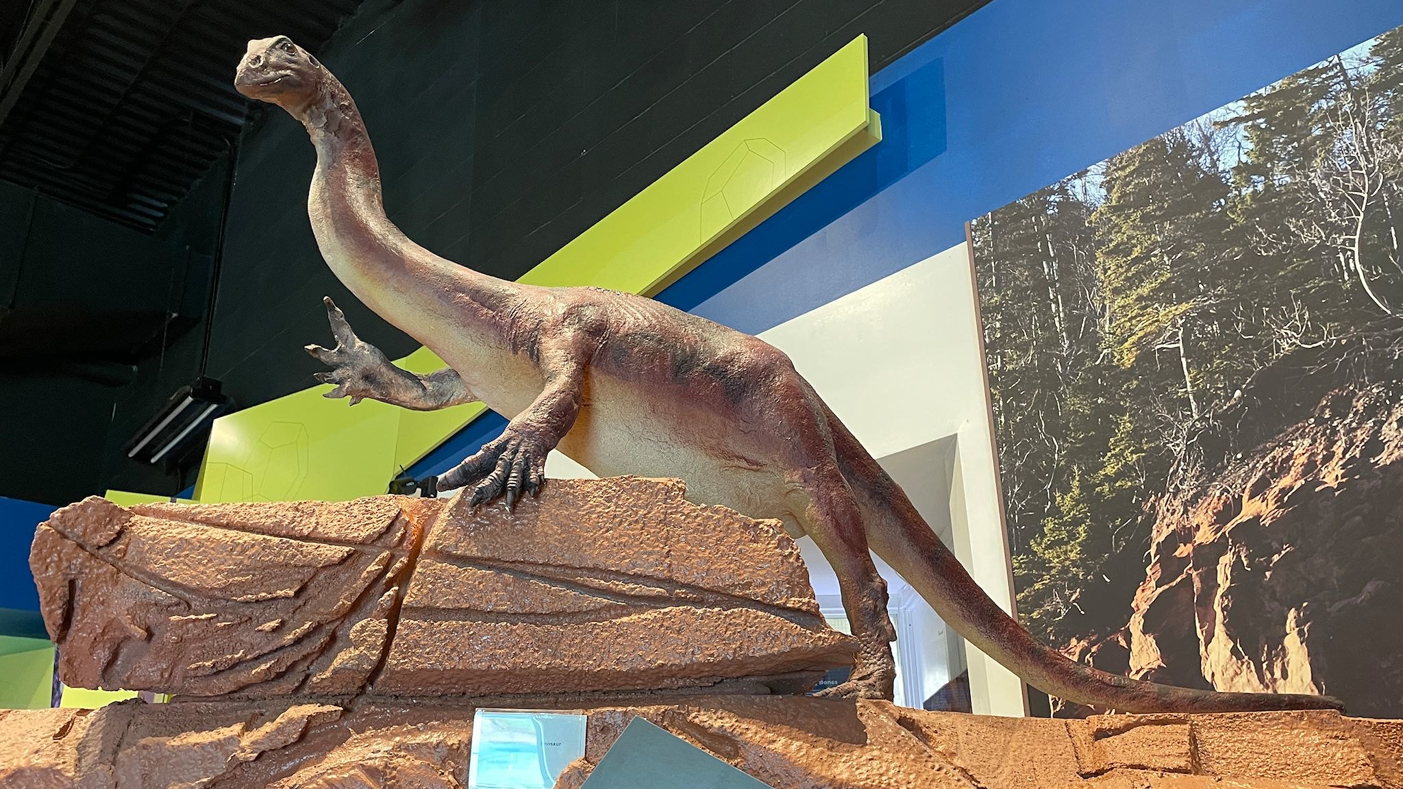
Although we were still on the shore of the Minas Basin, our first interpretive centre/museum stop heading north was all about… dinosaurs? Ok, yes – and the tides that help to uncover their fossils. The Fundy Geological Museum in Parrsboro has close ties to the Joggins Fossil Cliffs of Chinecto Bay (both are UNESCO World Heritage Centres), so let’s just start there.
I’ve always had a fascination with travel and for the past 20 or 30 years (give or take a few) whenever Doug or I learned of an interesting place to visit we put a pushpin on an electronic map. (It actually started with a little silver bucket with small pieces of paper and a pen on the bookshelf in our living room – our ‘Bucket List’ bucket – evolving from bookshelf to computer to The Cloud, but the concept still holds.) (We also keep track of the source of each so that friends who made the recommendations receive proper attribution.) Anyhow, as we got close to retiring those e-pushpins were nearly out of control. We’ve now spent a good part of the last 12 years reining things in, tracking and checking off the locations, marking some for a possible revisit, thanking the folks who sent us somewhere, and learning effective strategies to navigate our pushpin map.
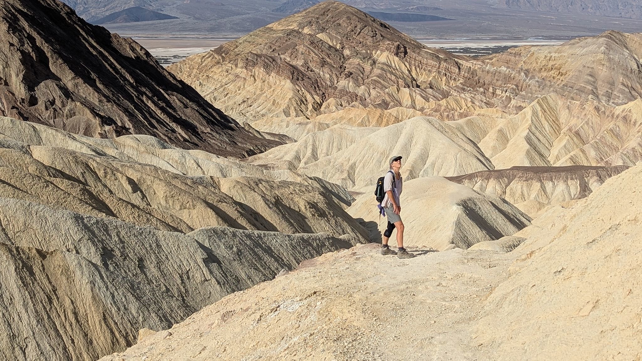
Sue along the Badlands Loop Trail in Death Valley National Park
We’d really wanted to see Death Valley National Park on this trip – that was right up at the top of our list of reasons for undertaking this repeat visit across the country. Once again, due to the government shutdown we didn’t quite know what to expect, and up-to-date information was hard to find. However, given our recent experience at Joshua Tree, and considering that from Bakersfield we were less than 3 hours from the park, we headed over to check it out. And once again, we were pleasantly surprised! The Death Valley Natural History Association is a non-profit that supports all of the goals of DVNP. They are funding park staff salaries during the shutdown, and the park was nearly fully open! And most of the closures were due to planned improvements or repairs to flood-damaged roads, unrelated to the current budget issues. Our heartfelt thanks to the DVNHA and all of the staff we met in the visitor center and campground for enabling us to have an amazing visit in Death Valley
We really wanted to visit Joshua Tree National Park as we head east. We didn’t know what to expect with the government shut down, and in this case we were pleasantly surprised. With the help of many volunteers and paid staff from the Joshua Tree National Park Association, a non-profit partner that provides support to JTNP to meet all of its goals, and a skeleton crew of National Park Service staff, the entire park was open and almost fully operational. We made sure to thank all of the volunteers and staff for their time and effort so that we could visit this wonderful place. Several thanked us back for having come despite the shutdown.
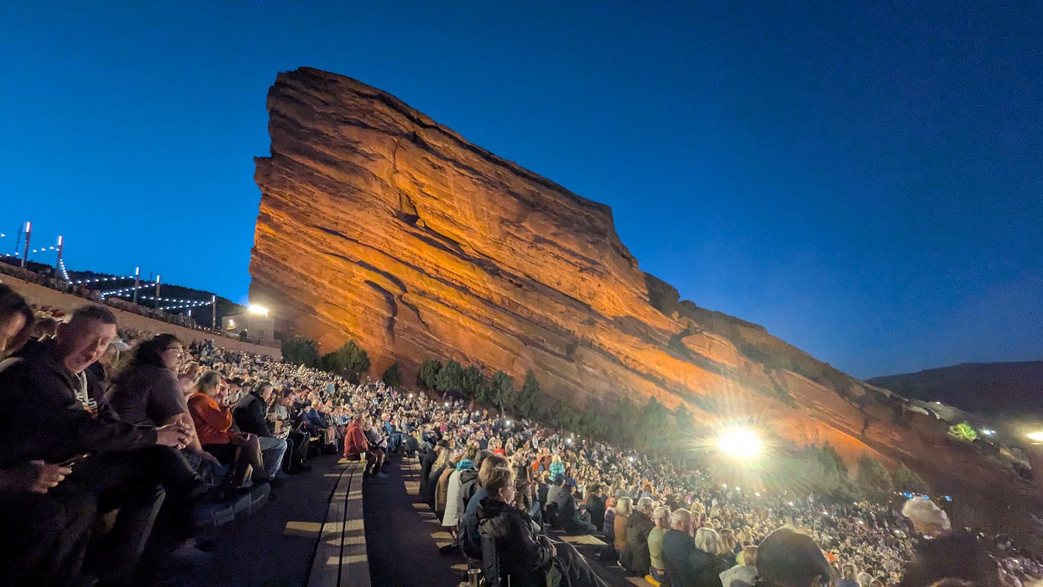
On my cross-country bike trip in 1983, I stopped in Morrison, CO. A local suggested I check out the Red Rocks Amphitheatre – a natural outdoor theatre that had been enhanced and turned into a performance venue. Although there was no show there that day/evening, it sounded like it might be a cool place to see, so I biked up to the entrance. I was in awe of this performance space tucked in between giant red rocks, surrounded by such stunning views! I spent the rest of the day hiking in and around the theatre.
Had there been a show, it would likely not have fit into my bike-bum’s budget. Sigh. Coming back someday to see a show was one of the first official items on my shiny new bucket list. It only took me 42 years to check it off!
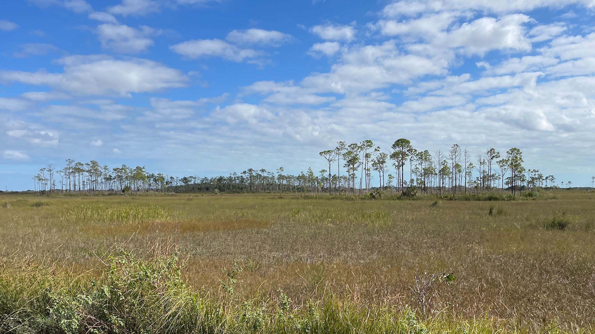
Slash pine ridges along the saw grass prairie of the Shark River Slough
Although we were glad to help my mom through her first-ever experience with surgery (at age 91!), we had to defer the latter 2/3rds of our planned southwest adventure. By the time my mom was stable (which happened very quickly, given the possibilities), there was no longer enough time to get back to any of those southwest plans. But we didn’t really need to rush home. Could we find a different adventure? What if we had planned a trip to the southeast… Is there something we would explore in Florida that we haven’t yet visited on our many family visits to Melbourne? This was a no-brainer – Everglades National Park!
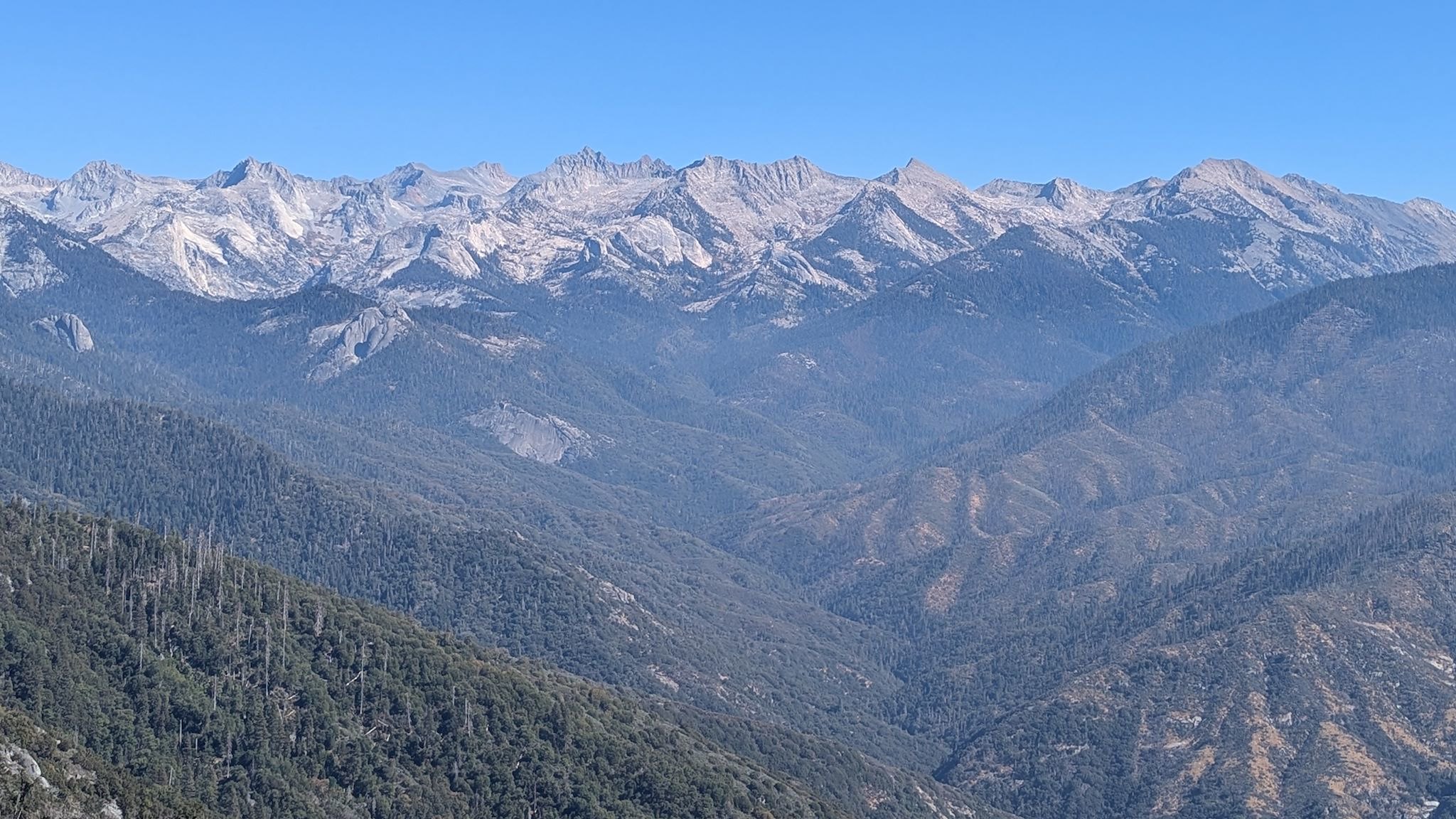
The Great Western Divide of the Sierra Nevada and headwaters of the Middle Fork of the Kaweah River
Sequoia National Park was established in 1890. This park includes Mt Whitney, the highest point in the lower 48 states at 14,505 feet above sea level, as well as 5 of the 10 largest giant sequoia trees. General Grant National Park was also established in 1890 to feature and protect giant sequoias, including the General Grant Tree. In 1940, in an effort to protect more of the unique resources of the area – the 14,000-foot peaks of the Sierra Nevada, Kings Canyon 10,000 feet below, as well as old-growth forests and other large groves of giant sequoia trees – the Kings Canyon National Park was created, incorporating General Grant National Park. Since 1943, the 2 national parks comprising nearly 1 million acres have been adminstered together as Sequoia & Kings Canyon National Parks.
We last visited Sedona in 2017 to see our long-time friends Malcolm and Judy, not long after they had retired and moved from New Jersey to AZ. They showed us around their new hometown and the surrounding areas, and, just as we always have, we looked forward to the next time we could get together. Then, in May 2021, Judy passed away. Her death was sudden and unexpected and very difficult for all who knew her, and we were deeply concerned for Malcolm, who’d lost his life partner of 49 years. Malcolm visited with us in VT later that summer on an east coast tour of visits with friends and countless private celebrations of Judy’s life, as he began to heal.
We were excited when we learned that Malcolm had met a wonderful woman, that they’d fallen deeply in love and were embarking together on a new chapter in their lives. Malcolm and Lita were married in May 2023, and we were eagerly awaiting our visit to meet and get to know Lita! Oh, and also Lita’s dog (now Malcolm’s step-dog) Cali.
Our change in plans afforded us 4 more days in which to choose a new adventure en route to Albuquerque. We spent three of them in Palo Duro Canyon State Park and loved every minute.
Palo Duro Canyon is the 2nd largest canyon system in the US, after (what else?) the Grand Canyon. Really? In the Texas Panhandle? Yup! It’s 40 miles long, averages 6 miles wide and drops 600 feet from the rim to the canyon floor.* The Prairie Dog Town Fork of the Red River cut the canyon over millions of year leaving behind caves, hoodoos and colorful rock and sandstone formations. Unlike the Grand Canyon, most of the action at Palo Duro takes place on the canyon floor.
Having just spent a fair amount of our touring and visiting time within sight of the ocean, or at least the sound of the waves, for our next bit of exploration we looked around for a place to visit that would take us away from the coast a bit to see a different part of Maine, if possible staying away from larger towns because that’s our M.O. We didn’t want to get too far inland, though, since most of the rest of our visits are also along the coast. Well, what’s that green splotch there on the map? That’s Bradbury Mountain State Park. Set a course…