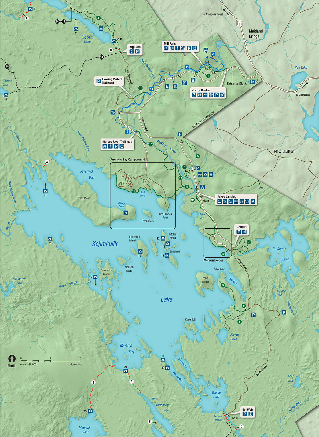
Gaspesie National Park

Mont de la Table/Tabletop Mountain

Parc National de la Gaspésie/Gaspesie National Park was created in April 1937 in order to permanently protect the Gaspésie caribou and the natural beauty and resources of the Chic Choc and McGerrigle Mountains, as well as the Rivière Sainte-Anne/Saint Anne River and its salmon. Part of the Applachian Mountains, the Chic Choc and McGerrigle ranges include the highest peaks in southern Quebec. The park is a mecca for hiking and is legendary for back country skiing.

What a surprise to learn that the Chic Chocs are also known as the Shick Shock Mountains…

Continue reading “Gaspesie National Park”

Forillon National Park

Gaspe Lighthouse

The Gaspe Peninsula is that long, thin blob of Quebec that extends along the southern shore of the St Lawrence River, to the north and east of Maine. This is funny – I knew it was on the St Lawrence, yet never noticed the south side of this peninsula before. The south side is along the Baie des Chaleurs (Bay of Warmth). I was surprised by the many similarities to the Cape Breton peninsula, though this makes sense given that the same geological events formed them both and both subsequently received similar shaping from the glaciers. The east side of Cape Breton/south side of Gaspe have a gentle slope to the sea/bay/ocean while the west/north sides are seemingly endless series of sharp cliffs plunging into the river/sea/gulf. And both have Parcs Canada national parks spanning the width of the peninsula. The road along the south side of Gaspe is dominated by beachy resort towns while the road along the St Lawrence passes through what appear to be mostly fishing towns with a few tourist offerings. There’s a 70-km/40-mi stretch where the road is sort of cantilevered into the St Lawrence at the base of the cliffs. The views are amazing! And as a bonus for the one who’s not driving (thanks Doug!), there are happy seals to be spotted sunning themselves on rocks all along the road.

Continue reading “Forillon National Park”

Kouchibouguac National Park

The Kouichibouguac National Park was designated in 1969 to preserve and protect a unique piece of New Brunswick’s Coastal Plain Ecosystem. The park has barrier islands that change with the tide and the wind, short sand dunes that are equally dynamic, lagoons, estuaries, salt marshes and tidal rivers that host aquatic and sea bird populations, ancient bogs and fields, and forests regenerating from past timber harvests. Its name is hard to spell, and pronouncing it is difficult enough that we needed coaching – fortunately, this was available from the helpful park staff.

Continue reading “Kouchibouguac National Park”

Cape Breton Highlands National Park

The Cape Breton Highlands comprise a tall, slightly rounded, mountainous plateau on the northeastern end of Nova Scotia. It was formed by the same collision of continents that created the unique mountains in Gros Morne National Park as well as the Appalachian Mountains, back in the really old days. Although not insanely tall at the highest point on White Hill (533 metres/1750 feet), the plateau drops dramatically from the edges – about 350 metres/1150 feet – to the ocean below.

Continue reading “Cape Breton Highlands National Park”

Terra Nova National Park

Newman Sound, Terra Nova National Park

Terra Nova National Park is situated on the northeast coast of Newfoundland. It encompasses 238 km/150 miles of shoreline, all of it within a north to south span of 45 km/30 miles and within 5 km/3 miles of the coast. It comprises islands, sounds, points, fjords, bogs, headlands, inlets, forests, ponds, fingers (of land), arms (of water), tickles (look it up), and straits. The park’s PR people share our penchant for superlatives… Brochures boast that Terra Nova is Canada’s easternmost National Park (yes, we’ve been to Pacific Rim National Park) and Newfoundland’s oldest, established in 1957 (Gros Morne was established in 1970). As with all National Parks, Terra Nova manages access to the beautiful parklands and its primary mission is conserving and restoring ecological integrity.

If Gros Morne is about the rocks, Terra Nova is about balancing the health of the forest that supports the critters that eat the lichen that grows on the rocks, the rocks down in the valley-o (oops, Newfoundland music…).

Continue reading “Terra Nova National Park”

Gros Morne National Park

Gros Morne Mountain

National parks in Canada are established to manage wild and natural spaces, and balance access for visitors to appreciate and enjoy while protecting and conserving their unique ecological offerings. We’ve come to especially appreciate them as beautiful places to learn more about nature and indulge in one of our favorite activities – hiking. Gros Morne checks all the boxes and more. Much more. Its global geological significance is mind blowing.

Continue reading “Gros Morne National Park”

Labrador 510 – Trans-Labrador Highway, part 2

Battle Harbour

The road to connect the settlements and resources of western and coastal Labrador – the Trans-Labrador Highway – had been in the works since the early 80’s. Dirt roads and walking trails between settlements were widened into gravel roads in sections, then paved as demand and budgets allowed. The last remaining section of gravel was paved in July, 2022 – and the road was complete!

Continue reading “Labrador 510 – Trans-Labrador Highway, part 2”

Saguenay Fjord National Park

Cap Trinité

Saguenay Fjord National Park spans both sides of the Saguenay River, providing educational programs and access to the famed escarpments and coves while protecting and managing the natural beauty of the area. At 100 km/60 miles in length, Saguenay Fjord is one of the largest fjords in the world. Its width ranges between 2 and 4 km/1.2 and 2.5 miles. The deepest point is 270 m/890 feet while the escarpments rise over 300 m/1,100 ft above the Saguenay River. The tallest of these at 411 m/1,348 feet is Cap Trinité/Trinity Cap, with its 3-plateau rock wall, at the edge of Baie Éternité/Eternity Bay.

Continue reading “Saguenay Fjord National Park”

Great Smoky Mountains National Park

Twilight over the Tennessee side of Great Smoky Mountains

Asked which is the most visited National Park in the country, most people would think it must be Yellowstone or Yosemite or some of the other large parks in the west. Nope! Great Smoky Mountains National Park takes the top spot. Its location – within a day’s drive of half the US population – and its incredible beauty attracted 14 million people in 2021. (Zion with 5 million and Yellowstone with 4.9 rounded out the top 3.)

GSMNP is a wide area in the Appalachian Mountains that spans the North Carolina and Tennessee border with a seemingly endless series of forested mountain ridges. The natural vegetation in the area releases organic compounds with a bluish tint that mix with the natural morning fog to create a blue-tinged, smoky appearance – hence the name. The park is well known for its views and waterfalls, its elk herd, and its hiking. Hiking!

Continue reading “Great Smoky Mountains National Park”