Homer

Homer, Homer Spit, Kachemak Bay, Kenai Mountains

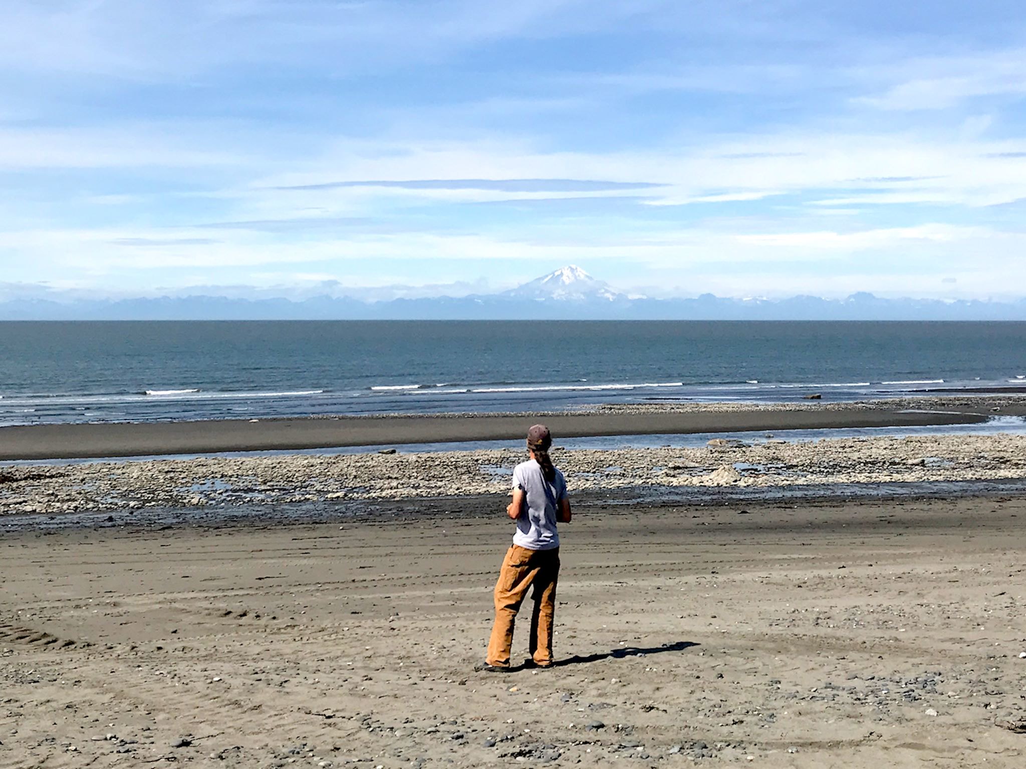
D’oh! No, not that Homer – Homer, AK. It’s a small town in a stunning location at the road’s end on the west side of the Kenai Peninsula. It’s situated where the Kachemak Bay empties into Cook Inlet, feeling cozy and protected by the Kenai Mountains interspersed with glaciers to the south and east, and the Alaska Range with its four towering volcanoes to the west. A key geological feature of the town is the Homer Spit, a terminal moraine left by the glacier that filled and carved out the Kachemak Bay 15,000 years ago. The Spit is a long, narrow, natural gravel bar that sticks out 4.5 miles into bay, now dotted with campsites and shops and people fishing.

We loved Homer! And that was all Duncan’s fault.

Continue reading “Homer”

Anchor Point

Welcome to Anchor Point – looking at Mount Redoubt across the water (and look at the tide…)

Après Salmonfest, we needed a chill day. Nonstop music and activity, rock-star hours – we were tired! After the last day of the festival, we decided to drive a whole 20 minutes south from Ninilchik to Anchor Point. This town boasts a campground at the beach and, significantly, the beach is the westernmost point in North America that you can drive to via highway. Cool!

Sounds like a nice chill day, eh? Yeah, right…

Continue reading “Anchor Point”

Chugach State Park

Symphony Lake and Eagle Lake

Chugach State Park is the third largest State Park in the country. It features 6000-foot peaks within sight of sea level. And it’s right outside Anchorage, where the population is 300,000 fortunate souls. Although there are access points to hiking trails and other recreation opportunities all around the park perimeter, including within the Anchorage city limits, there are three main access areas to explore – Eklutna Lake, Eagle River and Girdwood and we’d been given suggestions for great hikes in all three.

Continue reading “Chugach State Park”

Denali State Park

Denali

We made some good decisions, and we were lucky. What remained for us to explore in Alaska was the the Kenai Peninsula and Chugach Mountains south and east of Anchorage and a small area north of there that includes Denali State Park. The forecast for north of Anchorage was slightly better, so we headed that way.

Denali National Park protects the wilderness area around Denali, at 20,308 feet, the tallest mountain in North America. The smaller Denali State Park is just south of the National Park. There are three major attractions within the State Park – the Parks Highway with strategically situated view points, campgrounds and trailheads, the wide, braided, glacial Chulitna River, and the 37-mile long, open K’esugi Ridge – boasting views of Denali* from all three.

*But only on rare, clear days. We had two of them!

Continue reading “Denali State Park”

Hatcher Pass

The Bald Mountain Ridge, Government Peak, Matanuska Glacier in the distance from Hatcher Peak

Have you ever heard of Hatcher Pass? Neither had we. It’s the old (and only) mining road in the Talkeetna Mountains which are between the bigger and more well-known Alaska Range to the north and the Chugach Range to the south. It’s become a secret backcountry recreation area for outdoor enthusiasts of all kinds. Helen and Mike and Nick and JS thought we’d love it. Reason enough to head that way.

O. M. G. Exclamation point.

Continue reading “Hatcher Pass”

The Alaska Highway through British Columbia

Liard Hot Springs

Driving north from Dawson Creek, the scenery quickly transforms from agricultural to boreal forest. The Highway ribbons through the forest in what appears to be the path of least resistance (as it likely is – they built it in a hurry…) until reaching Fort Nelson. Except for Fort St John (pop 21,500) and Fort Nelson (pop 3,500), there are few stops. Most are service stops (fuel, food, post office, maybe a motel and/or RV park) like Pink Mountain (pop 8), pull-outs with historical info, or dirt side roads heading to gas and oil camps. Oh, and lots and lots of animals – bears, moose, caribou, stone sheep (like big horn sheep only smaller and darker), and elk – everywhere.

Continue reading “The Alaska Highway through British Columbia”

South Ontario

Lake Erie, Middle Island

So yes, the most direct route from Kalamazoo to Vermont goes through South Ontario, from Detroit to Buffalo. We’d not yet visited that part of Canada. And we had the time for one more adventure!

Of course, as is our nature, the first thing we did was make the direct route a little less direct… This tiny slice of Ontario touches three of the Great Lakes. We can see them all! And to do so, we used our proven-based-on-vast-experience, late season approach to planning – where can we find places to stay.

Continue reading “South Ontario”

Yellowknife, NT

Yellowknife is out there! On the north shore of the Great Slave Lake, it’s a 15-hour drive from Edmonton, AB and 5 hours from the nearest settlement with more than 2,000 people. Although geographically isolated, it’s by no means disconnected from the world. It’s a modern city of 20,000 of the most ethnically diverse, friendliest and interesting people we’ve met on our travels.

We’d made a campground reservation to stay a few days for the music festival, and we extended it a couple of times to do some more visiting and exploring of the city.

Continue reading “Yellowknife, NT”

Yellowknife, NT: Folk on the Rocks

When we first considered exploring Canada this year, I looked at the map. I had to use a big screen – Canada’s a big place! Just pondering the sheer size, I noticed a dot on the map at the end of a road to the north on the edge of a huge lake: Yellowknife, in the Northwest Territories. It was all by itself and way up there. Curious, I googled it. It is the northernmost city in Canada. You get there on the northernmost paved road in Canada. It is the home of Folk on the Rocks, the ‘largest music festival under the midnight sun.’ We wanted to explore the Canadian Rockies in August/September. If we went to Yellowknife, the timing of the festival in late July would be perfect! We put a pushpin on the map and I made our only reservation of the summer at the campground next door to the festival grounds. We’re very glad we did!

Continue reading “Yellowknife, NT: Folk on the Rocks”

North Manitoba – The Pas, Snow Lake

Wekusko Lake near Snow Lake, MB

North? We’re getting somewhere! Winnipeg, in southeastern Manitoba, is north of the northernmost point we visited in North Ontario. The province considers anything north of the 53rd parallel North Manitoba, and describes it as ‘a vast untamed wilderness’ which sounds like our kinda place. So from Winnipeg, we headed north…

Continue reading “North Manitoba – The Pas, Snow Lake”