Death Valley National Park

Sue along the Badlands Loop Trail in Death Valley National Park

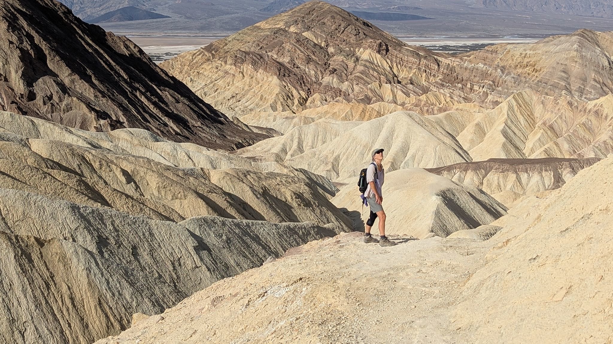
We’d really wanted to see Death Valley National Park on this trip – that was right up at the top of our list of reasons for undertaking this repeat visit across the country. Once again, due to the government shutdown we didn’t quite know what to expect, and up-to-date information was hard to find. However, given our recent experience at Joshua Tree, and considering that from Bakersfield we were less than 3 hours from the park, we headed over to check it out. And once again, we were pleasantly surprised! The Death Valley Natural History Association is a non-profit that supports all of the goals of DVNP. They are funding park staff salaries during the shutdown, and the park was nearly fully open! And most of the closures were due to planned improvements or repairs to flood-damaged roads, unrelated to the current budget issues. Our heartfelt thanks to the DVNHA and all of the staff we met in the visitor center and campground for enabling us to have an amazing visit in Death Valley

Continue reading “Death Valley National Park”

Joshua Tree National Park

Dancing Joshua Tree

We really wanted to visit Joshua Tree National Park as we head east. We didn’t know what to expect with the government shut down, and in this case we were pleasantly surprised. With the help of many volunteers and paid staff from the Joshua Tree National Park Association, a non-profit partner that provides support to JTNP to meet all of its goals, and a skeleton crew of National Park Service staff, the entire park was open and almost fully operational. We made sure to thank all of the volunteers and staff for their time and effort so that we could visit this wonderful place. Several thanked us back for having come despite the shutdown.

Continue reading “Joshua Tree National Park”

Brown vs. Board of Education National Historic Park – Topeka, KS

Monroe Elementary School, Topeka KS

On our last trip through Kansas (nine years ago!), we wrote that Kansas had no national parks for us to see. That changed in 2022 – and that change has (so far) withstood our government’s renewed scrutiny of National Park Service facilities.

Continue reading “Brown vs. Board of Education National Historic Park – Topeka, KS”

Big Cypress National Preserve

Lots of alligators

As we left Everglades National Park, we drove west through Big Cypress National Preserve. It’s another million acres of wetlands, though deeper and with slower moving water. Yes, the folks at Cypress are proud of their swamp! The National Preserve status allow for more recreational usage (compared to a National Park) so fossil fuel exploration and extraction, hunting, and off-road vehicle use are all permitted. There are also parcels of land withing the preserve that are privately owned, and traditional uses by the indigenous Seminole and Miccosukee tribes also take place.

Continue reading “Big Cypress National Preserve”

Everglades National Park

Slash pine ridges along the saw grass prairie of the Shark River Slough

Although we were glad to help my mom through her first-ever experience with surgery (at age 91!), we had to defer the latter 2/3rds of our planned southwest adventure. By the time my mom was stable (which happened very quickly, given the possibilities), there was no longer enough time to get back to any of those southwest plans. But we didn’t really need to rush home. Could we find a different adventure? What if we had planned a trip to the southeast… Is there something we would explore in Florida that we haven’t yet visited on our many family visits to Melbourne? This was a no-brainer – Everglades National Park!

Continue reading “Everglades National Park”

Sequoia & Kings Canyon National Parks

The Great Western Divide of the Sierra Nevada and
headwaters of the Middle Fork of the Kaweah River

Sequoia National Park was established in 1890. This park includes Mt Whitney, the highest point in the lower 48 states at 14,505 feet above sea level, as well as 5 of the 10 largest giant sequoia trees. General Grant National Park was also established in 1890 to feature and protect giant sequoias, including the General Grant Tree. In 1940, in an effort to protect more of the unique resources of the area – the 14,000-foot peaks of the Sierra Nevada, Kings Canyon 10,000 feet below, as well as old-growth forests and other large groves of giant sequoia trees – the Kings Canyon National Park was created, incorporating General Grant National Park. Since 1943, the 2 national parks comprising nearly 1 million acres have been adminstered together as Sequoia & Kings Canyon National Parks.

Continue reading “Sequoia & Kings Canyon National Parks”

Gaspesie National Park

Mont de la Table/Tabletop Mountain

Parc National de la Gaspésie/Gaspesie National Park was created in April 1937 in order to permanently protect the Gaspésie caribou and the natural beauty and resources of the Chic Choc and McGerrigle Mountains, as well as the Rivière Sainte-Anne/Saint Anne River and its salmon. Part of the Applachian Mountains, the Chic Choc and McGerrigle ranges include the highest peaks in southern Quebec. The park is a mecca for hiking and is legendary for back country skiing.

What a surprise to learn that the Chic Chocs are also known as the Shick Shock Mountains…

Continue reading “Gaspesie National Park”

Forillon National Park

Gaspe Lighthouse

The Gaspe Peninsula is that long, thin blob of Quebec that extends along the southern shore of the St Lawrence River, to the north and east of Maine. This is funny – I knew it was on the St Lawrence, yet never noticed the south side of this peninsula before. The south side is along the Baie des Chaleurs (Bay of Warmth). I was surprised by the many similarities to the Cape Breton peninsula, though this makes sense given that the same geological events formed them both and both subsequently received similar shaping from the glaciers. The east side of Cape Breton/south side of Gaspe have a gentle slope to the sea/bay/ocean while the west/north sides are seemingly endless series of sharp cliffs plunging into the river/sea/gulf. And both have Parcs Canada national parks spanning the width of the peninsula. The road along the south side of Gaspe is dominated by beachy resort towns while the road along the St Lawrence passes through what appear to be mostly fishing towns with a few tourist offerings. There’s a 70-km/40-mi stretch where the road is sort of cantilevered into the St Lawrence at the base of the cliffs. The views are amazing! And as a bonus for the one who’s not driving (thanks Doug!), there are happy seals to be spotted sunning themselves on rocks all along the road.

Continue reading “Forillon National Park”

Kouchibouguac National Park

The Kouichibouguac National Park was designated in 1969 to preserve and protect a unique piece of New Brunswick’s Coastal Plain Ecosystem. The park has barrier islands that change with the tide and the wind, short sand dunes that are equally dynamic, lagoons, estuaries, salt marshes and tidal rivers that host aquatic and sea bird populations, ancient bogs and fields, and forests regenerating from past timber harvests. Its name is hard to spell, and pronouncing it is difficult enough that we needed coaching – fortunately, this was available from the helpful park staff.

Continue reading “Kouchibouguac National Park”

Cape Breton Highlands National Park

The Cape Breton Highlands comprise a tall, slightly rounded, mountainous plateau on the northeastern end of Nova Scotia. It was formed by the same collision of continents that created the unique mountains in Gros Morne National Park as well as the Appalachian Mountains, back in the really old days. Although not insanely tall at the highest point on White Hill (533 metres/1750 feet), the plateau drops dramatically from the edges – about 350 metres/1150 feet – to the ocean below.

Continue reading “Cape Breton Highlands National Park”