The Dalton Highway, aka The Haul Road

Trucker coming over Atigun Pass

OK! Who wants to hear about our 1000-mile excursion out and back on a (mostly) great, (mostly) gravel road? It totally rocked!

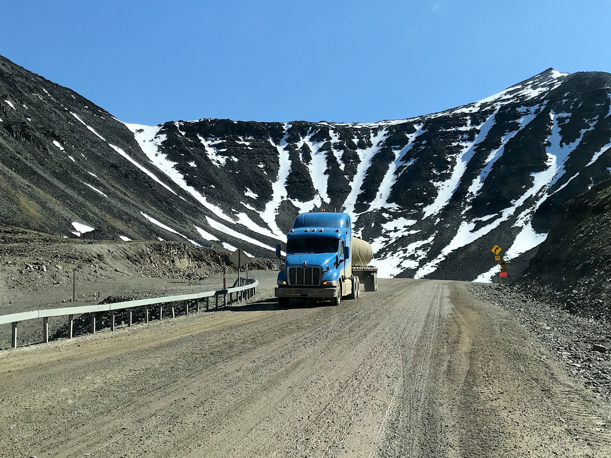
The James W. Dalton Highway, originally known as the North Slope Haul Road and now also known as Alaska Route 11, is the northernmost road in all of North America. It is one of the most remote roads in the US. We did some research before deciding to drive it. Guide books, including the Dalton Highway Visitor Guide, all mention the challenges of the drive and warn about rough gravel, no shoulders, steep grades, trucks, flat tires, broken windshields, breakdowns (and waiting for days for a tow truck), lack of services, no cell coverage, and that you could die. The Wikipedia entry: ‘Anyone embarking on a journey on the Dalton is encouraged to bring survival gear.’ We checked in again with Ed and A-J who drove the highway last year: ‘Yeah, you’ll love it!’

Continue reading “The Dalton Highway, aka The Haul Road”

Fairbanks

We’ve known Nick for a pretty long time. He was 2 months old when we first visited Stump Sprouts, the World’s Greatest B&B, owned by his parents Lloyd and Suzanne in the Berkshires. Little did we know at the time, that visit would evolve into a same-time-next-year, Memorial Day get-together with a group of close friends for over 30 years. Through the years, we got to know Nick initially as a little guy hanging around, then a kid who could come on some of our shorter bike rides, then as a teen who’d kick our butts on our longer bike rides. Then, he was off to college. Although we saw less of him, Lloyd and Suzanne kept us updated. As a young adult ready to take on the world as a nordic ski coach and continue living his outdoor adventure lifestyle, Nick moved around a bit, settling in Fairbanks.

We checked in with Nick. C’mon over!

Continue reading “Fairbanks”

Delta Junction – Mile 1422 and the end of the Alaska Highway

Welcome to the end of the Alaska Highway!

A bit more than two weeks after leaving Mile 0 in Dawson Creek, BC, we arrived in Delta Junction, AK, at Mile 1422 and the official end of the Alaska Highway. Unlike Dawson Creek, where RVs line up for pix of the start and much of the town’s activity is focused on this unique claim to fame, there’s not usually much of a line at the highway’s end in Dalton Junction. Many travelers split off once in Alaska at Tok, choosing one of three directions, so there are fewer and far more distributed tourists arriving in Delta Junction, though we did see another RV during short our visit. And of course we did take the required Mile 1422 marker photo!

Continue reading “Delta Junction – Mile 1422 and the end of the Alaska Highway”

Side trip to Alaska!

Ribbon of highway along the Three Guardsmen Pass

When people think of Alaska, a lot of us think first of the Interior – that huge landmass that includes Fairbanks and Denali, just south of the polar bears. There’s also southeastern Alaska, also called the Inland Waterway or the Inside Passage or the Alaska panhandle. It’s a bunch of beautiful islands and peninsulas, featuring rain forests in close proximity to glaciated mountains. Our friend Gail who previously lived in Haines loved it and recommended a visit.

Fascinating and beautiful it is, but travel in southeast Alaska is primarily via the Alaska Marine Highway (aka ferries), cruise boats, and airplanes. It’s tough to visit southeast Alaska driving an RV! There are but two roads, for a total of 246 paved miles. One connects Whitehorse (which we’d just departed en route to Haines Junction, YT) with Skagway, AK, 100 miles to the south. The other 146 miles make up the Haines Highway which connects Haines Junction, YT (where we just happened to be) with Haines AK.

Continue reading “Side trip to Alaska!”

The Alaska Highway along the 60th parallel

Sign at border crossing near Contact Creek

Along the Alaska Highway between Liard River, BC and Whitehorse, YT there are two small towns, a few service stops, and (as the highway crosses back and forth across the border) Welcome to British Columbia! and Welcome to Yukon! signs abound- making it no doubt the friendliest, least inhabited space we’ve ever visited. The Highway more or less follows the 60th parallel, crossing between BC and YT six times before definitively crossing into Yukon just south of Whitehorse.

We entered Yukon for the first time at Contact Creek. As with many major transportation projects – the Canadian Pacific Railroad, Transcontinental Railroad in the US, the Channel Tunnel – work crews on the Alaska Highway started at both ends and worked toward each other, connecting in September 1942 at a place known ever since as Contact Creek.

Continue reading “The Alaska Highway along the 60th parallel”

The Alaska Highway through British Columbia

Liard Hot Springs

Driving north from Dawson Creek, the scenery quickly transforms from agricultural to boreal forest. The Highway ribbons through the forest in what appears to be the path of least resistance (as it likely is – they built it in a hurry…) until reaching Fort Nelson. Except for Fort St John (pop 21,500) and Fort Nelson (pop 3,500), there are few stops. Most are service stops (fuel, food, post office, maybe a motel and/or RV park) like Pink Mountain (pop 8), pull-outs with historical info, or dirt side roads heading to gas and oil camps. Oh, and lots and lots of animals – bears, moose, caribou, stone sheep (like big horn sheep only smaller and darker), and elk – everywhere.

Continue reading “The Alaska Highway through British Columbia”

Revelstoke, BC/Mount Revelstoke National Park

Lake Eva in Mount Revelstoke National Park

The grand concept for this trip was to make our way to the Canadian Rockies, visit (and hike!) the national parks there, and start making our way back. As Doug detailed in the two previous posts, we extended our westerly turn-around point to Penticton and added a music festival in Salmon Arm, both in BC. In addition to the five Rocky Mountain parks, we included the two national parks in the Selkirk range in our list, just a bit west of the Rocky Mountains in BC. The first of these is Mount Revelstoke National Park.

Continue reading “Revelstoke, BC/Mount Revelstoke National Park”

Yellowknife, NT

Yellowknife is out there! On the north shore of the Great Slave Lake, it’s a 15-hour drive from Edmonton, AB and 5 hours from the nearest settlement with more than 2,000 people. Although geographically isolated, it’s by no means disconnected from the world. It’s a modern city of 20,000 of the most ethnically diverse, friendliest and interesting people we’ve met on our travels.

We’d made a campground reservation to stay a few days for the music festival, and we extended it a couple of times to do some more visiting and exploring of the city.

Continue reading “Yellowknife, NT”

Wood Buffalo National Park (NT/AB) and Fort Smith, NT

Pine Lake in Wood Buffalo National Park

Wood Buffalo National Park is the largest national park in Canada and the fifth largest national park in the world.* How large? It’s nearly 45,000 sq km (17,300 sq mi). How large is that? By comparison, Yellowstone, one of the larger national parks in the US, is approximately 9,000 sq km (3,500 sq mi), just 20% of the size of WBNP. Like Yellowstone, WBNP is significant on a world scale. It’s the home of the largest free-roaming wood bison herd in existence, the only nesting area for the remaining wild population of whooping cranes and the largest freshwater delta supporting four waterfowl migration routes across North America. Oh, and it’s home of the world’s largest beaver dam, 850 metres (2,700 feet) wide.

They had me at ‘Buffalo.’

Continue reading “Wood Buffalo National Park (NT/AB) and Fort Smith, NT”